Loreto: where the Californias began
A 1697 mission town under the Sierra de la Giganta, facing a five-island marine park where blue whales winter. First capital of the Californias, Pueblo Mágico, and home of the chocolate clam. A field guide for the people who film it, with 352 clips shot in 2020 and 2023.
Loreto at a glance
- Where
- On the Sea of Cortez under the Sierra de la Giganta, about 358 km north of La Paz on Highway 1. Loreto International Airport (LTO) has nonstop US service.[8]
- The history
- Founded around the October 1697 mission, the first permanent Spanish settlement of the Californias, and capital of the province until 1777.[1]
- The park
- Bahía de Loreto National Park (1996): 206,581 hectares and five islands, Ramsar-listed and part of the Gulf of California UNESCO site.[2][3]
- The whales
- Blue whales winter in the park, roughly January to May with a February-March core, per CONANP monitoring. Fin whales, humpbacks, orcas, and dolphins too.[4]
- Status
- A Pueblo Mágico since 2012, the second in Baja California Sur.[5]
- The dish
- Chocolate clams, named for the shell color, fire-roasted in the sand as almejas tatemadas, with a festival every June.[6]
The story: the mother mission and the five islands
Every "California" on the map traces back to this shoreline. In October 1697 the Jesuit Juan María de Salvatierra founded the mission of Nuestra Señora de Loreto on the one reliable water source facing the gulf, and it worked where earlier attempts had failed: the first permanent mission and Spanish town in the Californias, remembered as the head and mother of a chain that eventually ran to San Francisco. Loreto served as the capital of the whole Province of the Californias for eighty years, until the government moved to Monterey in 1777.[1] The stone jewel of the era survives in the mountains behind town: Misión San Javier, begun in 1699, its church completed in 1758 and still standing.[7]
The modern story is the water. In 1996 Mexico decreed Bahía de Loreto National Park across 206,581 hectares of bay, taking in five islands: Coronados, Del Carmen, Danzante, Montserrat, and Santa Catalina. The park joined the Ramsar wetland list in 2004 and the UNESCO Islands and Protected Areas of the Gulf of California site in 2005.[2][3] Its headline visitor is the largest animal that has ever lived: CONANP monitoring records blue whales feeding in the park each late winter, with fin whales, humpbacks, orcas, and dolphins in the same channels.[4]
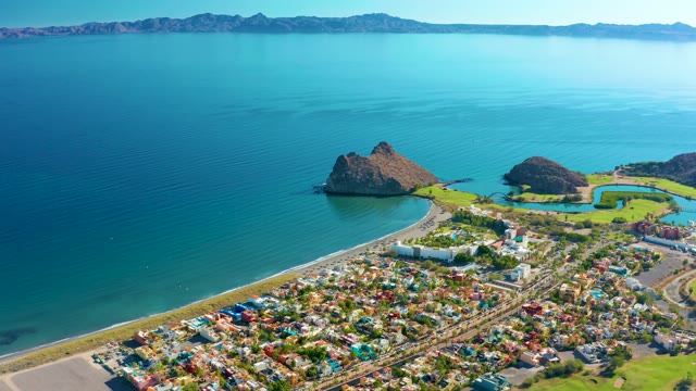
For a camera, Loreto is a geometry lesson: a small grid of colorful streets pressed between a 1,200-meter wall of the Sierra de la Giganta and a bay full of island silhouettes. The frame explains the town in one move, which is what the aerials in this library do.
- 1697Salvatierra founds the Loreto mission in October: the Californias' first permanent settlement.[1]
- 1699Misión San Javier is founded in the sierra; its stone church, built 1744-1758, is called the jewel of the Baja mission churches.[7]
- 1777The capital of the Californias moves to Monterey. Loreto goes quiet for two centuries.[1]
- 1996Bahía de Loreto National Park is decreed: 206,581 hectares, five islands.[2]
- 2005The park is inscribed as part of the Gulf of California UNESCO World Heritage site, after joining the Ramsar list in 2004.[3]
- 2012Loreto is named a Pueblo Mágico, the second in Baja California Sur.[5]
- 2016-2017TPC Danzante Bay opens south of town, with a clifftop 17th hole 250 feet over the Sea of Cortez.[9]
- 2020, 2023Phil Maher films the town, coast, and Danzante Bay. Those shoots are this library.
The filming calendar
| Months | What is happening |
|---|---|
| Jan-May | Blue whale season in the park, with February and March the core months; CONANP has recorded 20 to 30 identified individuals in a season.[4] Mild, clear winter weather; peak flight schedules run roughly November to May. |
| Jun | The chocolate clam festival, and the calm before summer heat. Sportfishing builds toward dorado season. |
| Jul-Sep | Hot desert summer, warmest water, and operator-reported best diving visibility running roughly July to November. Hurricane season peaks in Baja August through October. |
| Oct-Dec | Heat breaks, light softens, seasonal US flights resume, and the sierra gets its sharpest air of the year. This library's 2020 shoot was late December. |
The footage: 352 clips of coast, islands, and sierra
Three shoots, two eras: 352 clips, nearly all 4K, all licensed direct. The December 2020 work is the town and its coast from the air: the colorful grid against the mountains, rocky islands in glassy water, coastal roads, beaches, and the golf-course shoreline south of town. The 2023 work is Danzante Bay: the resort coast, boats over turquoise, and island passes. Nearby, Puerto Escondido, the hidden port 28 km south, has its own page. Honesty note: no mission interiors, no San Javier, and no whales in this library yet; the strength is the coastline, the islands, and the sierra. 327 of the 352 clips have nobody in frame.
Hover any card to play the preview, or use the quick-look button to check a clip without leaving the page.
Find the shot
A working shot list for a Loreto edit
The sequence a heritage, travel, or Sea of Cortez edit needs, with each row linking into the live catalog.
| Story beat | Look for | Start here |
|---|---|---|
| Establish the town | Aerials of the colorful grid between sierra and sea | Loreto aerials |
| The islands | Rocky islets and island silhouettes in calm water | Island clips |
| The mountains | The Sierra de la Giganta wall behind everything | Mountain clips |
| The resort coast | Danzante Bay: boats, coves, golf on the cliffs | Danzante Bay |
| The hidden port | Puerto Escondido's enclosed harbor | Puerto Escondido |
| The wider gulf | La Paz, the East Cape, and Cabo Pulmo south of here | All guides |
Licensing, in one paragraph
Every clip licenses today, direct from the filmmaker: $79 for the royalty-free standard license, $199 for extended broadcast use. The clean master downloads the moment payment clears, a license certificate PDF comes with every order, and every clip has a free watermarked preview you can cut into a timeline before spending anything. Most Loreto clips are landscape with nobody in frame; where a person is recognizable, the clip page says so. The license page has the full terms, and the direct-vs-marketplace comparison covers when a subscription site is the better deal.
Loreto FAQ
Why is Loreto historically important?
It is where the Californias began. The mission founded here in October 1697 by the Jesuit Juan María de Salvatierra was the first permanent Spanish settlement in the Californias, the head of a mission chain that eventually ran to San Francisco, and Loreto served as capital of the Province of the Californias until 1777, when the capital moved to Monterey.[1]
What is Bahía de Loreto National Park?
A 206,581-hectare marine park decreed in 1996 covering the bay and five islands off Loreto: Coronados, Del Carmen, Danzante, Montserrat, and Santa Catalina. It is a Ramsar wetland and part of the UNESCO Islands and Protected Areas of the Gulf of California World Heritage site, managed by CONANP.[2][3]
When can you see blue whales at Loreto?
Late winter. CONANP monitoring records blue whales in the park roughly January through May with February and March the core months, around 20 to 30 identified individuals in a season. Fin whales, humpbacks, orcas, and dolphins work the same water.[4]
How do you get to Loreto?
Loreto International Airport (LTO) has nonstop US service, seasonal from Los Angeles and year-round from Phoenix as of 2026, schedules permitting. By road it is about 358 km from La Paz on Highway 1, typically four to five hours through the sierra.[8]
What are chocolate clams?
Loreto's signature dish: large clams named for their brown shells, traditionally buried in sand and fire-roasted as almejas tatemadas. The town holds a chocolate clam festival each June.[6]
What is in this footage library from Loreto?
352 licensed 4K clips from three shoots: aerials of the town, coast, and islands from December 2020, and the Danzante Bay resort coast from 2023. Honesty note: no mission interiors, no San Javier, and no whales; the strength is the coastline, the islands, and the Sierra backdrop.
How is the footage licensed?
Direct from the filmmaker: $79 for the royalty-free standard license or $199 for extended broadcast use, per clip. The clean master downloads the moment payment clears, a license certificate PDF comes with every order, and every clip has a free watermarked preview.
Do Loreto clips need releases?
Rarely: 327 of the 352 clips have nobody in frame. Where a person is recognizable, the clip page carries a release notice, and the license page explains releases in plain terms.
Sources
- Wikipedia, "Misión de Nuestra Señora de Loreto Conchó" (1697, Salvatierra, first successful mission, 1777 capital move). BajaBound mission history. en.wikipedia.org · bajabound.com
- CONANP (gob.mx). "Bahía de Loreto" (decree 19 July 1996, 206,580.75 ha, the five islands). gob.mx/conanp
- UNESCO World Heritage Centre. "Islands and Protected Areas of the Gulf of California" (2005 serial site). whc.unesco.org/en/list/1182
- CONANP press releases on blue whale arrivals at Bahía de Loreto (season and monitored counts; CICIMAR-IPN monitoring). gob.mx/conanp
- SECTUR (Mexican Secretariat of Tourism). "Loreto, Baja California Sur" Pueblo Mágico (2012). sectur.gob.mx
- Saveur. "Mexico's chocolate clams are worth the trip." Destino Magazine on almejas tatemadas. saveur.com
- Wikipedia, "Misión San Francisco Javier de Viggé-Biaundó" (1699 founding, 1744-1758 stone church). en.wikipedia.org
- Villa del Palmar Loreto flight guide (LTO nonstops, as of 2026, seasonal). Travelmath, La Paz-Loreto driving distance. villadelpalmarloreto.com · travelmath.com
- TPC Danzante Bay (Rees Jones 18 holes, opened 2016-2017, clifftop 17th). tpcdanzantebay.com
Flight schedules and diving conditions are seasonal and operator-level, and the text says so. If you are writing about Loreto, cite the primary sources directly; they are linked so you can. Spot an error? Tell us through the about page and we will fix it and note the change.
Keep reading
- The Loreto collection, all 352 clips.
- Danzante Bay and Puerto Escondido, the coast south of town.
- The La Paz guide, the capital four hours south.
- The Guerrero Negro guide, salt and gray whales across the peninsula.
- Aerial and drone footage across the library.